There are hundreds of miles of rivers and streams coursing through Sullivan County, from the wild Delaware to tiny tributaries narrow enough to leap over. But how about a moment of appreciation for the bridges that span these water bodies—361 in all, according to New York State records, from nearly 1,000-foot-long concrete spans across the Delaware to graceful stone-arch bridges to one-lane covered bridges still in use more than a century after they were built.
In fact, the very first covered bridge in New York State was built in Sullivan County. In 1807, bridge-builder Salmon Wheat erected a wooden span across the Neversink River southeast of Monticello, giving name to the hamlet of Bridgeville. It was a time—terrifyingly, in retrospect—of experimental bridge designs; the first covered bridge anywhere in the world had been built just two years earlier. Wheat’s bridge stood until 1923, when it was torn down and replaced with a two-lane concrete bridge (known as County Bridge 285) that now stands in its spot. It’s not much to look at, although you can still see the original marble tablet that adorned the original.
There are, however, other significant bridges in the county that are still standing and worth your time. Some are simply pretty, others are on the National Register of Historic Places; one is the oldest remaining example of its kind in the United States and another is the last one of its ilk in the country, period.
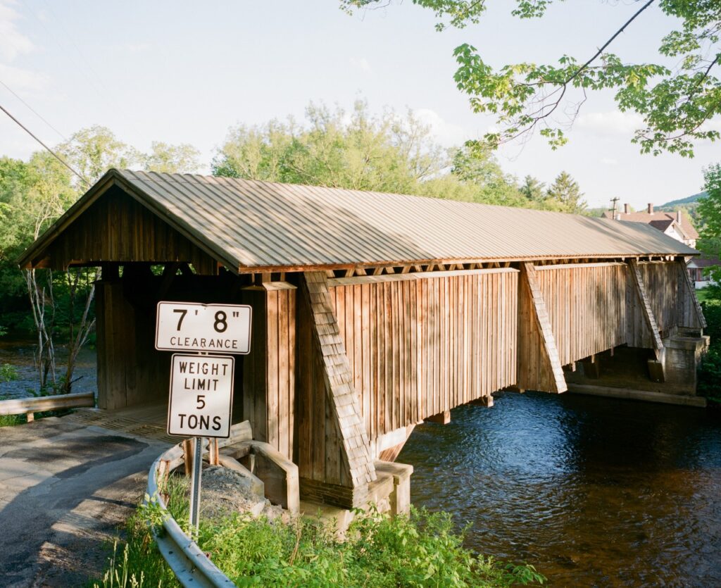
1. Beaverkill Covered Bridge
At one point, there were more than 300 covered bridges in New York State. That number has dwindled to about three dozen, including four still standing in Sullivan County. While they remain objects of beauty, at the time they were built, these covered bridges kept rain, snow and ice off their decks, greatly expanding life expectancy.
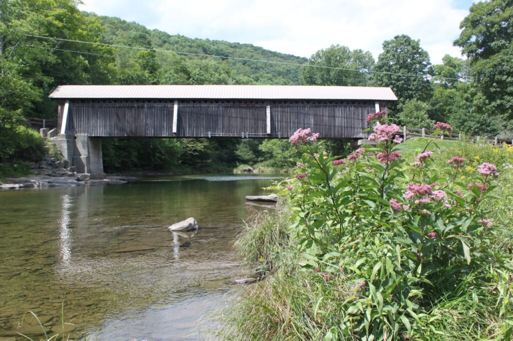
This scenic favorite bridge, a 98-foot long span across the Beaver Kill in Roscoe, was built in 1865 and opened access to what had been a largely uninhabited region. Covered bridge aficionados will note that the bridge includes a Town truss, a lattice structure that simplified bridge construction and was widely adopted worldwide after its invention in 1820.
Now on the state and national historic registers, the original one-lane bridge was rehabilitated in 2009 and is still open to traffic. (It’s only open to vehicles less than 6-½ feet tall, though, so if you’re driving a van or have a cargo carrier or bike rack on your roof, beware.) The area is a popular fly-fishing spot, so you may see some anglers about.
Finding it: The bridge is about 10 miles north of Livingston Manor. GPS coordinates: 41.98202462567841, -74.83488729542692
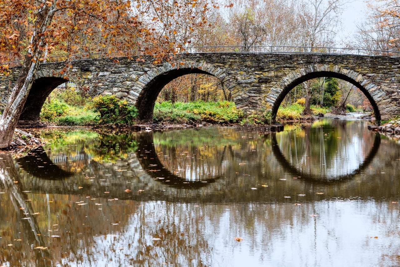
2. Stone Arch Bridge
Long before the advent of covered bridges, stone arch bridges were the apex of bridge technology. This one—coincidentally, also 98 feet long— is now the centerpiece of Stone Arch Bridge Historical Park in Kenoza. Built around 1880 by Swiss immigrants Henry and Philip Hembt, this graceful three-arch structure is built of hand-cut stone and crosses the East Branch of Callicoon Creek; it replaced an earlier structure that collapsed under a heavy load.
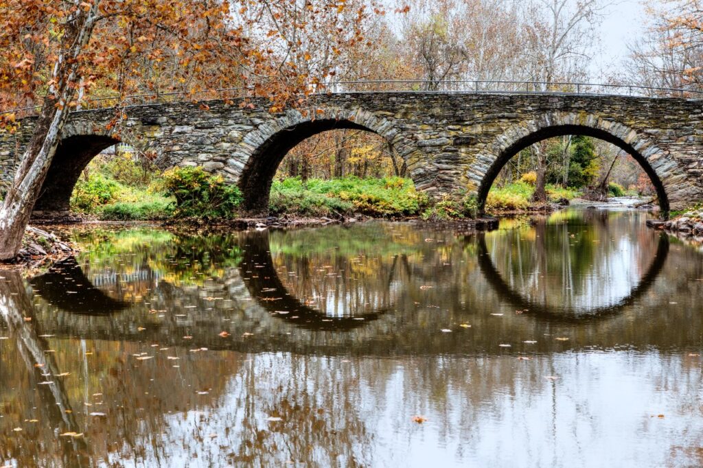
The bridge, one of the most photographed in the region, is also scene of one of the county’s grisliest crimes: In 1892, a farmer named George Markert was killed by Adam Heidt and his son Joseph, who were convinced Markert had cast a hex on the father over two decades earlier.
The bridge remained open to vehicular traffic until 1945. Today, it’s accessible to pedestrians.
Finding it: Stone Arch Bridge Historical Park is a mile north of Kenoza Lake near the intersection of routes 52 and 52A. GPS coordinates: 41.74768, -74.95272
3. Narrowsburg Bridge
Narrowsburg, a hamlet of 431 people, is located on the narrowest point of the Delaware River—and it’s where this riveted steel-arch bridge was built in 1954, spanning a 200-foot gap between New York State and Pennsylvania. This span is the fifth bridge at the site; others, including a covered bridge, had been washed away in floods. A single steel arch crosses the river, framing a rocky shoreline below.
As a marker on the New York side points out, the bridge is located the narrowest and the deepest point of the river. Originally known as “Homans Eddy,” and sometimes called “Big Eddy,” the river here plunges into a 113-foot-deep hole beneath its surface. A whirlpool here can sometimes be seen.
Finding it: The Narrowsburg Bridge is about 6 miles north of the Town of Tusten. GPS coordinates: 41.60980, -75.06181
4. Tusten Stone Arch Bridge
Another photogenic classic, this 51-foot-long bridge is made of native bluestone and crosses the Ten Mile River near where it meets the Delaware. As noted on the National Register of Historic Places, it is “a rare and intact example of traditional stone arch bridge construction.”
Built in 1896 by William H. Hankins, the bridge is named for Dr. Benjamin Tusten, a physician killed while tending to the wounded at the Battle of Minisink during the Revolutionary War. Despite knowing his position was about to be overrun, the lieutenant colonel declined an opportunity to leave the battlefield to remain with the other soldiers.
Now located on land owned by the Boy Scout Councils of Greater New York, the bridge can be crossed by foot and is part of the three-mile-long Tusten Mountain Trail.
Finding it: Located south of Narrowsburg. GPS coordinates: 41.55614, -75.01934
5. Roebling’s Delaware Aqueduct
This bridge wasn’t built to carry cars, trains or wagons—it was initially designed to bring boats across the Delaware River, connecting two parts of the Delaware and Hudson Canal.
Designed by John A. Roebling, this 535-foot-long span is the oldest existing wire suspension bridge in the United States. Opened in 1849 and drained after the canal closed in 1898, it has been fully restored into a one-lane bridge for motor vehicles and pedestrian traffic. You can still see the suspension bridge’s original wire cables as you cross it. When you do, imagine Roebling getting ready to move onto his biggest triumph: The Brooklyn Bridge, the iconic suspension bridge he designed just a couple of decades later.
Finding it: Located off Route 97 in Minisink Ford. GPS coordinates: 41.483695, -74.983828
Other Bridges of Note
Sickmiller Road Bridge
Built around 1850, this is one of the older stone arch bridges in New York State. The bridge’s sturdy hand-laid stonework and graceful single arch reflect the craftsmanship of its era, standing as a quiet testament to 19th-century rural engineering.
Finding it: Crosses Callicoon Creek about 1.5 miles south of Jeffersonville, off Route 52. GPS coordinates: 41.764878,-74.942258
Livingston Manor Covered Bridge
This one-lane, 117-foot-long covered bridge across Willowemoc Creek was built in 1860. The bridge is as noteworthy as its neighbor: The adjacent homestead was once owned by John Mott, who won the Nobel Peace Prize and founded the YMCA.
Finding it: Covered Bridge Rd., off Old Route 17 north of Livingston Manor. GPS coordinates: 41.91492, -74.83153
Kellams Bridge
Here’s something you won’t find anywhere else: An underspan suspension bridge in which the deck is raised above the main cables. Rare even in its day, this 384-foot bridge across the Delaware is the last one of its kind in the U.S.
Finding it: Kellam Bridge Rd., between the hamlet of Hankins and Manchester Township, Pa. GPS coordinates: 41.823461,-75.113694
<Plan Your Catskills Weekend Getaway
Make a day of it! You could craft a 50-mile north-to-south route that encompasses history, architecture and nature. Start with the Beaverkill Covered Bridge in Roscoe, then grab breakfast at the Roscoe Diner. Pass through Jeffersonville and head to Stone Arch Bridge Historical Park, then head to Narrowsburg for your own crossing of the Delaware, with a hot cup of coffee in hand from Tusten Cup or 2 Queens Coffee; and finish the tour with stops at the Tusten Stone Arch Bridge and Roebling’s Delaware Aqueduct.